DRAFT Maps I and O.T.


UNDER CONSTRUCTION FOR SPRING 2011
 

Middle East Map | Israel | Palestinian Occupied Territories

URL of this web page: http://web.cocc.edu/cagatucci/classes/hum213/Maps/DRAFTMapsIOT.htm


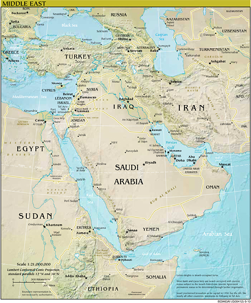
Middle East

"Middle East" [Map]  [middle_east2010.jpg]
https://www.cia.gov/library/publications/the-world-factbook/maps/refmap_middle_east.html

"Middle East" [Map: PDF version]:
https://www.cia.gov/library/publications/the-world-factbook/graphics/ref_maps/pdf/middle_east.pdf


Work Cited

"Middle East." [Map.] "References: Regional Maps: Middle East." The World Factbook. CIA - Central Intelligence Agency. 2011. Web. 25 Jan. 2011. <https://www.cia.gov/library/publications/the-world-factbook/maps/refmap_middle_east.html>.


Israel


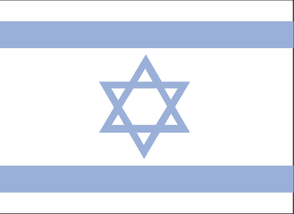
Israel "Flag Description: with a blue hexagram (six-pointed linear star) known as the Magen David (Shield of David) centered between two equal horizontal blue bands near the top and bottom edges of the flag; the basic design resembles a Jewish prayer shawl (tallit), which is white with blue stripes; the hexagram as a Jewish symbol dates back to medieval times" ("MIddle East: Israel" [Flag]).


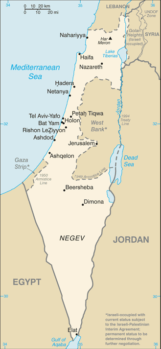
Middle East: Israel [Map]

"Middle East: Israel" [Map]  [is-map.gif]
https://www.cia.gov/library/publications/the-world-factbook/maps/maptemplate_is.html


Works Cited and Recommended

"Middle East: Israel." The World Factbook. CIA - Central Intelligence Agency. 2011. Web. 25 Jan. 2011. <https://www.cia.gov/library/publications/the-world-factbook/geos/is.html>.
[Abstract: Includes country Introduction (Background) | Geography | People | Government | Economy | Communications | Transportation | Military | Transnational Issues; and links to Flag | Photos | Map/s]

"Middle East: Israel." [Flag.] "Library: Publications: Middle East: Israel: Flag." The World Factbook. CIA - Central Intelligence Agency. 2011. Web. 25 Jan. 2011. <https://www.cia.gov/library/publications/
the-world-factbook/flags/flagtemplate_is.html>.

"Middle East: Israel." [Map.] "Library: Publications: Regional Maps: Middle East: Israel." The World Factbook. CIA - Central Intelligence Agency. 2011. Web. 25 Jan. 2011. <https://www.cia.gov/library/publications/the-world-factbook/maps/maptemplate_is.html>.


Palestinian Occupied Territories

West Bank & Gaza [Strip]


Map showing the West Bank and Gaza Strip in relation to central Israel (situation of 2007)

[URL: http://en.wikipedia.org/wiki/File:West_Bank_%26_Gaza_Map_2007_(Settlements).png ]


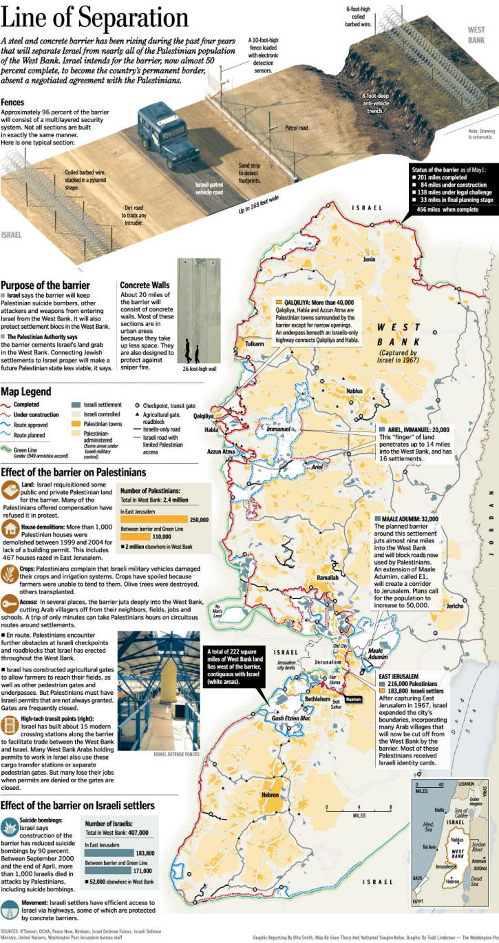
West Bank: Line of Separation


Line of Separation

In 2002, Israel began constructing a 456-mile barrier to separate it from nearly all the Palestinian population of the West Bank. Click on the map below for a detailed look at the barrier system.

Washington Post Map x x x  (situation as of 2006)

[URL: http://www.washingtonpost.com/wp-dyn/content/graphic/2006/05/30/GR2006053000018.html

Two Peoples, Divided (2007): URL: http://www.washingtonpost.com/wp-srv/world/interactives/barrier/
Abstract: "These articles examine how Israelis and Palestinians are living increasingly separate lives in a land they have sought unsuccessfully to share."  [ http://www.washingtonpost.com/wp-srv/world/interactives/barrier/ ] Series of Washington Post Reports entry via links embedded in interactive map

"Language Lost" [caption:] "Fewer and fewer Palestinians and Israelis are bothering to learn the other's language.  Who continues to do so and why suggests how the two peoples view their future together"
 Link to related article:
Wilson, Scott.  "In Mideast, a Growing Linguistic Divide: Unable to Achieve Peace, Israelis and Palestinians Pull Apart."  Washington Post Foreign Service, 1 April 2007.  Web. 26 Dec. 2010. <http://www.washingtonpost.com/wp-dyn/content/article/2007/03/31/AR2007033101104.html>.

"Economic Split" [caption:] "Israel has shut down most commercial links with Palestinian territories, where the economy has imploded while Israel's has thrived."
 Link to related article:

The Architect:

Ancient Claims:

Israel Revisited:

Anxious Partners:

Walls Within Fractured Land: http://www.washingtonpost.com/wp-srv/world/interactives/barrier/

Walls Within: "For Israel's Arab Citizens, Isolation and Exclusion: Israel's policies have deepened the gulf between Arab and Jewish citizens through concrete walls, laws that favor Jews, and political proposals that place Arab minority outside national life"

Fractured Land: "Under Pressure, Palestinian Territories Pull Apart:  Influenced by Israeli policy and Hamas' power, the West Bank and Gaza Strip are developing distinct political, cultural and economic identities, threatening the future unity of a Palestinian state."


Urban Divide:


One Land, Two Peoples - Washington Post

Begin:

Israeli-Palestinian Conflict: Two Peoples Divided [Index]

URL: http://www.washingtonpost.com/wp-dyn/content/linkset/2005/04/14/LI2005041400716.html

Israel and the Mideast Conflict

URL: http://www.washingtonpost.com/wp-dyn/content/article/2006/07/17/AR2006071701076.html

----Separated Within
Graphic | In Israel's northern region, where Arab citizens outnumber Jews, Israel separates the two communities by segregating towns, erecting walls and applying laws that favor Jews. These policies have deepened the gulf between Jews and Arabs.

URL: http://www.washingtonpost.com/wp-dyn/content/graphic/2007/12/20/GR2007122000207.html


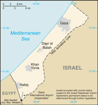
https://www.cia.gov/library/publications/the-world-factbook/maps/maptemplate_gz.html

https://www.cia.gov/library/publications/the-world-factbook/geos/gz.html


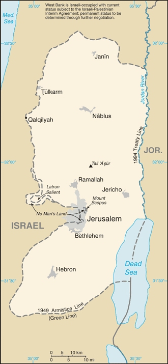
Middle East: West Bank [Israeli-Occupied Territory permanent status TBD]

https://www.cia.gov/library/publications/the-world-factbook/maps/maptemplate_we.html

https://www.cia.gov/library/publications/the-world-factbook/maps/maptemplate_we.html

https://www.cia.gov/library/publications/the-world-factbook/geos/we.html

"Israel." Map. The 2010 World Factbook. CIA - Central Intelligence Agency. 2010. Web. 19 Dec. 2010. <https://www.cia.gov/library/publications/the-world-factbook/maps/maptemplate_is.html>.

"Middle East: Israel." The 2010 World Factbook. CIA - Central Intelligence Agency. 2010. Web. 19 Dec. 2010. <https://www.cia.gov/library/publications/the-world-factbook/geos/is.html>.


Lebanon

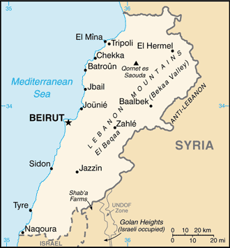
Lebanon: https://www.cia.gov/library/publications/the-world-factbook/maps/maptemplate_le.html

Lebanon (country page): https://www.cia.gov/library/publications/the-world-factbook/geos/le.html


"Israel." Map. The 2010 World Factbook. CIA - Central Intelligence Agency. 2010. Web. 19 Dec. 2010. <https://www.cia.gov/library/publications/the-world-factbook/maps/maptemplate_is.html>.

"Middle East: Israel." The 2010 World Factbook. CIA - Central Intelligence Agency. 2010. Web. 19 Dec. 2010. <https://www.cia.gov/library/publications/the-world-factbook/geos/is.html>.


You are here:  HUM 213 Maps 2: Israel and Palestinian Occupied Territories + related resources
URL of this webpage: http://web.cocc.edu/cagatucci/classes/hum213/Maps/Maps2.htm
Last Updated: 08 April 2011

© 1997 - 2011, Cora Agatucci, Professor of English
Humanities Department, Central Oregon Community College
Please address comments on web contents & links to:
If you have technical website errors or problems, please contact: